TALES FROM THE TRAIL (AND SOMETIMES THE ROAD TOO)

Showing posts with label Santiago Truck Trail. Show all posts

Thursday, March 18, 2021

STT

IMG_6563IMG_6569IMG_6573

Saturday, March 13, I got out early for some trail time after two days of rain. The storm brought snow to our local mountains. Though I love hiking through snow (a light snow), my only possibilities of hiking in the snow were: 1) Maple Springs out of Silverado (which was under voluntary evacuation due to mudslides), 2) Trabuco Canyon/Holy Jim (which is still closed from #HolyFire), or 3) Drive to the top of the mountain to Blue Jay campgrounds (which was not a good choice for a few reasons, mainly because I kind of hate driving the windy Ortega Highway, especially the part when I’m right up against a cliff and the driver behind me is riding my tail, pressuring me to drive faster!) All other locations, if it got any snow, I figured most likely would have melted by morning.  And so I chose a location that few people would choose mainly because there’s so few places to park – Santiago Truck Trail (STT). What a lovely, lovely desolate trail.

I was on the road early enough to find parking in a turnout up Modjeska Canyon not too far from the trailhead. Having checked the weather ahead of time, I expected cold. I didn’t quite imagine though that it would feel this cold. The weather reports said 38F in Silverado, so I’m going to go with that (but it seemed colder!)  I know 38F is not so cold for a lot of people. For this native Californian, it’s pretty cold. And I wasn’t prepared, so I had to walk back to the truck for more warmth. (I guess that means I was prepared being that I had warmer accessories back at the truck.)

And so, with an insulated beanie and much warmer buff (doubled up with my thinner buff), my journey continued to “Old Camp” via STT. It makes my heart glad to even think of the loneliness of this trail. From the start, I took the high single track, though it had been bulldozed and was difficult at first to locate. It’s important that I take this high trail on the way out – it’s my habit, and I love, love, love the “backbone” portion pictured above (first picture).

Talk about quiet. I saw only a couple of people in those early hours. They rode bikes. Through the clouds that covered the peaks, I could see snow on the slopes. The Main Divide I am certain was covered with snow. As for STT, a few small patches of melting snow dotted the shady side of the road as I approached my turnoff point at Joplin. That was it as far as snow. I could hear the creek flowing strong far below my trail and in the distance across the canyon a small waterfall flowed over the boulders (@ approximately mile 5) that I plan to try and reach some day soon. 

IMG_6586IMG_6610

IMG_6616

At times the weather grew so cold and the clouds so dark that it felt eerie. Hard to explain really. The word “spooky” comes first to my mind. Nature is surreal even more so during these eerie times. I was happy to see anyone that I met along the trail, as first, they were a confirmation that I was not so crazy to be out on this lonely trail by myself, and also because it was comforting to see the face of another person after travelling in silence for some miles. After mile 4, human sightings became rare. I came upon a group of several young men headed down to “Old Camp”. A lone male hiker with poles passed me at one point on Joplin Trail.

IMG_6646

The turnoff to “Old Camp” @ Joplin Trail is at about mile 6 on Santiago Truck Trail. At that point, I’d already hiked some significant hills, so the joy was instant upon reaching this junction. The relief of finally reaching this point was short-lived however, because after a short descent, the ascent begins once again. It’s two and a half miles to “Old Camp” at this junction. A very long 2.5 miles. But the last mile, so delightful it was, doesn’t really even count. On that final mile descent into “Old Camp”, the moss appears in thick mounds beneath the trees which are also covered in a moss carpet. Lush green ferns fill in the spaces between rock and moss and the wonderfully aromatic Bay leaf trees begin to appear on the landscape in abundance. I stopped to cut a small branch of the Bay Leaf to take home with me, as I always do.

Heading Down Into “Old Camp”

IMG_6656IMG_6659IMG_6663

By the time I arrived to “Old Camp”, the cyclists who had passed me along the way had already passed me on their way out. As expected, I was completely alone down in this little shaded paradise next to the stream. I remained in that general area for quite some time, knowing that I was pushing it as I always do time-wise. I ate breakfast, unpacked and re-packed, explored some, took pictures and I also just sat. I sat and waited. Waited for what? Nothing. I just waited. And I listened. And I prayed. It was spooky down there I admit. But it was also peaceful and a little magical. I will say that I was quite pleased when a young couple rode in on their bikes and set up their spot not too far from me, closer to the stream. It was nice talking to people after being silent for so long.

Total miles for this adventure: 17 with 3,000’ of elevation gain

The remainder of the story in pictures:

Down By “Old Camp”:IMG_6672IMG_6682IMG_6687IMG_6691IMG_6695IMG_6699

The long hike back:

IMG_6702IMG_6723IMG_6724IMG_6736IMG_6743IMG_6770IMG_6777IMG_6789

Saturday, March 21, 2020

Empty Grocery Shelves & An Order To Social Distance

This past Tuesday, March 17, we got another break in rains. We were not in a statewide shelter-in-place order yet, but practically everything had closed down: schools, libraries, bars, dine-in restaurants, theaters, gyms, sports, concerts, etc. From what I see around me, no one is in a panic -- no one I talk to, none of my family members. But there is a lot of public discourse if you have any of the apps or belong to your community's social media pages. People are posting angrily and want everyone to stay inside of their homes. Hunker down! On Tuesday, "Social Distancing" was the order of the day -- that is don't meet in groups, publicly or privately, and stay at least 6 feet from one another outside of your family. I thought local mountains were the perfect place of course, to social distance myself. 

I decided to take drive up Santiago Canyon Road and turn off into Modjeska Canyon. That took about thirty minutes. I was aiming for a shortish hike, so I was in no rush and could enjoy the drive -- I found it calming. I parked off to the side of the road along Modjeska Grade, which was a short uphill distance (about 1/4 mi) away from Santiago Truck Trail. It's an asphalt hike to the trail head with this gorgeous view overlooking the homes off of Modjeska Grade and Santiago Canyon Rd:


Santiago Truck Trail (STT) is the perfect trail when I want short distance (as in about 7 miles). Of course, STT is good for long distances too, as there's Joplin Trail and Old Camp off Yonder! It's a beautiful trail and it never gets old. My heart sang on Tuesday the moment my feet hit the dirt. I  was very much in the mood to toughen it up and didn't hesitate to take the higher, more difficult single track that backbones up above Santiago Truck Trail.  What gorgeous views!


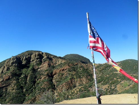
Meeting back up with STT the views did not disappoint. I took it to the flags across from the vulture crags. It's mainly uphill on the way out, except for this one grand sweeping downhill that meets up with The Luge Trail. There were no more than a half dozen mountain bikers over those 7+ miles (but I really think the number was more like 4). Either way, STT was a tranquilizer, and a easy pill to swallow at that. What a contrast it was up there to what's going on down here. Up there (on Santiago Truck trail) there's beauty surrounding. There's majesty. There's history. There's respect. What a great escape to what's going on down here. Down here, need I say, there's a disruption, a major disruption. There's empty grocery shelves and an order to social distance.

STT never gets old. And I think it even gets better in the midst of a pandemic. 

7.12 miles, 1,409' elevation gain.

Social Distancing


Friday, October 19, 2018

Santiago Truck Trail

While packing for last Friday’s hike (10/12), I noticed a leak in my pack’s bladder. It was hard NOT to notice; the outpour, though small and thin, was forceful. My cat did it. My husband had warned me that he had seen him swatting at my pack here and again. So, there I was, my day off Friday, ready for a hike with a leaky bladder. Fortunately, I had planned a relatively short hike, and could spare going off to the store for a new bladder. I was calm and I was collected because I almost always plan my trail adventures days in advance and knew I had time to spare. Note: calm and collected I am not always, which is why I try and plan things out in advance. (Planning is one of the best remedies for anxiety).

As it turned out, I arrived about twenty minutes before the running store opened. I needed a way to waste time -- because I couldn’t just sit in my truck for 20 minutes (though I should because it really needs cleaning and organizing – really! It is a complete mess) Anyway, I stopped in at Trader Joes, which is in the same parking lot, for some groceries. They were sold out of the items first on my list, so with slightly growing frustration I purchased some nuts (we are a huge nut lover family) and dried salami. Finally, I was back at the running store, purchased myself a new Ultimate Direction bladder ($32) and headed off to the mountains. Santiago Truck Trail that is.
IMG_4432Mid October is the start of autumn in Southern California. We still have warm days, but it’s definitely cooling down. And the mornings, they are sometimes cold. Autumn is the best time to hit Santiago Truck Trail again. There’s hardly any shade, but that’s okay now, it’s all okay now. SmileAutumn is here. And then after that we have winter, and then spring . . . summer is far, far away.

IMG_44931I hiked an out-and-back (with a bit of running) out to the flags across from the vulture crags. On the way, I took two detours – 1) up to a strange cross-like monument, and 2) to a second set of flags, The US flag and the California flag. The trip totaled 7.23 miles with 1,363’ feet of gain. As my hike progressed, enormous white clouds began to appear and the breeze blew cooler It was wonderful. Simply wonderful.

It did not occur to me then that the giant clouds were a hint of something good to come. That night back at home, rain began to fall. And it continued to fall for most of Saturday. And all the plants rejoiced! (As did I).

IMG_4531IMG_4538IMG_4552

And because this was a Friday hike, the video clips put to music. 

Saturday, January 28, 2017

SST in the Green

I find it very difficult to wake early on the weekends nowadays. But being that I want to get back into shape, and weekends are the only time to run mountain trails, I grudgingly woke at 6:00 am. And then I promptly tapped the phone screen for a nine minute snooze. And then I did it again, and again, and again, and again. I wasn’t out the door until 9:30 am. So much for setting the alarm.

Due to the fact that I got such a late start, I decided on Santiago Truck Trail (STT). The reason this is such a good trail to run on late-start mornings is because it only takes about thirty minutes to drive there – and more importantly, it’s paved the entire way, with no off-roading. To add a special touch – the drive is delightful, with a turn off into Modjeska Canyon and a windy drive through a couple of tree canopy tunnels.

So, I didn’t do what I had planned today. I didn’t beat myself up over it. At least I was out there, and got to wander about in the wilderness. Even saw three runners that I know on STT. And the hills were so lush and green. Absolutely beautiful. I wasted a lot of time pulling the camera out of my pack.

Miles: 7.22, Elevation gain: 1,376’

SAMSUNG CAMERA PICTURESSAMSUNG CAMERA PICTURESSAMSUNG CAMERA PICTURESSAMSUNG CAMERA PICTURESSAMSUNG CAMERA PICTURESSAMSUNG CAMERA PICTURES1 28 17a1 28 17